About the Your Move Journey Planner

The Your Move Journey Planner (powered by SkedGo) combines cutting-edge, technology with open-source data to revolutionise the way you plan to move around your local area. Our new improved Journey Planner now offers you a seamless, multimodal, personalised trip planning experience on your device of choice. 

The multi-modal Your Move Journey Planner uses the TripGo platform, produced by mobility technology company Skedgo, to help you find more ways to get from A to B. You can use any combination of local public transport (bus, train, ferry) with private and other transport modes such walking, bike riding, car, taxi, or even motorbike.

Screen capture of the Your Move Journey Planner

This award winning web-based trip planning technology delivers information on predicted departure and arrival times, GPS based locations of public transport stops and routes and indicative pricing to provide you with a complete journey planning experience.   
 
 You can adjust your user settings to prioritise saving money, saving time, helping the environment, for more convenience or to get more exercise. You can also make it remember your favourite places and even prioritise active travel or public transport over the car.

Step by step instructions:


1 - Enter your starting point and destination

Plan your journey by entering into the fields on the Journey Planner

  1. The starting point where you’re leaving from. You can choose either your current location or an address you define, and; 
  2. The destination that you want to go to. Note that its automatically set at Leave Now, but you can select to leave at another date and time, or arrive at a certain date and time.

2 - Choose which transport modes to include

Next, set which transport modes you want to include in your journey plan by clicking the Transport options button to choose from walking, bike riding, train, bus, taxi, ferry, car or the best combination of all. It’s your choice! The ones 'greyed out' wont be included in your journey plan.

3 - Personalise the results based on your  priorities

Finally, you can filter the results by the things you most value. You can choose to prioritise the fastest journey, the cheapest, the healthiest option or the most sustainable transport choice, saving you time, money or the planet. You can also save your preferences, making it easier and quicker next time.

Frequently Asked Questions

Where does the data come from for the bike routes suggested?

The bike data for the Your Move Journey Planner (powered by Skedgo) comes from Open Street Maps (OSM). The public are welcome to make suggested changes to the OSM data if they see any issues with the network and Skedgo will endeavour to incorporate them into the journey planner within a few weeks.    


If I see an issue with a bike route on the Journey Planner, who can I report it to?

The general public are welcome to make suggested changes directly to Open Street Maps themselves if they see issues with the network. Skedgo will endeavour to incorporate them into the trip planner in a timely manner. Alternatively, reports can also be sent to the Department of Transport (DOT) for inclusion in a future data provision to OSM.    


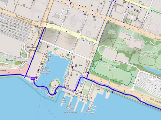
What do the blue lines and blue dots refer to on the bike map for a planned bike journey?

When you have planned a bike journey, you will see your route depicted with a dotted line, along with lots of blue lines on the map to describe the footpath and shared path network that is currently added to OSM. The small blue dots on the map refer to bike rack locations.  


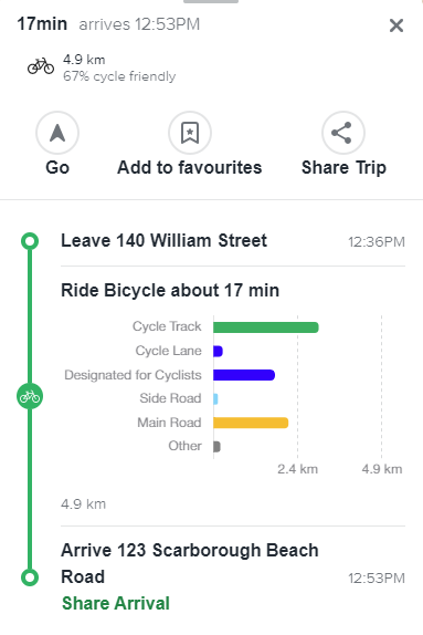
What do the green lines, blue lines and other coloured lines refer to on the ‘Details’ option for a bike journey?

 When you plan a bike journey and click on the ‘Details’ option, you are provided with an indicative breakdown of the types of infrastructure that your planned journey may comprise. This includes ‘cycle lanes’, ‘cycle network’ (footpaths and shared paths) and infrastructure that is ‘designated for cyclists’ (footpaths, shared paths and high quality shared paths.


How do you determine if a section of a bike journey is ‘designated for cyclists’, or is a side road etc?

This data is sourced from OSM, and the tags are attached to each “waypoint” along the route”. Here is an example of bicycle tags. https://wiki.openstreetmap.org/wiki/Bicycle_tags_map     


Where do you get the public transport information from, is it accurate and in real time?

 Transperth provide this data through the freely available ‘General Transit Feed Specification’ (GTFS). For real-time data around where your train or bus is currently located along your planned route, please download the Transperth App


How do you calculate the CO2 data?

To learn more about how we calculate CO2 (i.e. the carbon emissions), please refer to the information sheet provided by Skedgo on this link


How do you calculate the calories used?

To learn more about how we calories used in a journey option, please refer to the information sheet provided by Skedgo on this link


How do you calculate the public transport fares?

This data is provided through the GTFS data feed provided by Transperth


How do you calculate the car costs for a journey?

For fuel costs, Skedgo uses a calculation using the cost per kilometre which has two components:

  • Fuel cost per km
  • Vehicle maintenance per km cost:

The fuel cost is set at AUD 1.69 per litre or USD 1.13 per litre and this value was collected from the Global Petrol Prices website in 2024.

https://www.globalpetrolprices.com/Australia/gasoline_prices/

The vehicle maintenance cost is set at $0.66 per km* for Australia and the data was collected from RAC - Royal Automobile Club of WA     

*Note: These vehicle maintenance values were last updated in 2023:


How do you calculate the taxi fare costs?

Taxi information is derived from from http://www.transport.wa.gov.au/taxis/taxi-fares.asp

Metropolitan taxi fares - Effective from 3 May 2024 (GST inclusive)


Tariff 1 - Monday to Friday, 6am to 6pm

Flagfall $5.40

Distance rate  $2.13 per km

Waiting time $61.00 per hour


Tariff 2 - Monday to Friday, 6pm to 6am. Friday 6pm to Monday 6am. All day public holidays

Flagfall $7.70

Distance rate  $2.13 per km

Waiting time $61.00 per hour


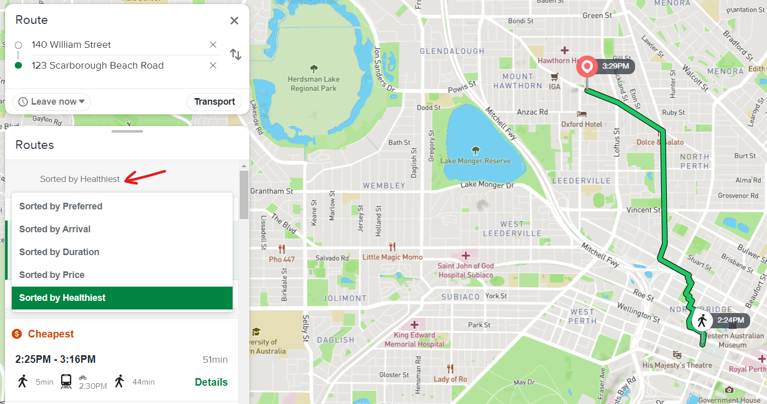
What does “sort by preferred” mean?

This is sorting based on your preferences that can be set in the webapp. Click on the ‘hamburger’ menu in the top left - Profile - Priorities.

Image of user preferences in webapp. 


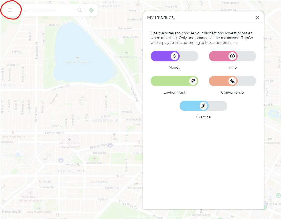
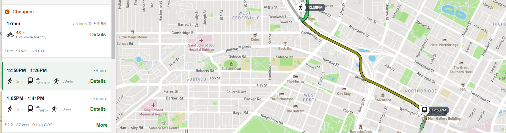
How can I sort by most environmentally sustainable option?

You can put the environment slider in the screenshot to the highest setting.

Image of the 'environmental' setting in the user preferences.


Why don’t we have the option to choose Rideshare or eScooter hire?

Some other jurisdictions have added Rideshare or eScooter hire locations to their TripGo data, and while this data may be integrated at a later date, however at this stage there are no plans to add this data to the Your Move Journey Planner (powered by Skedgo).